

SPARTA - Officials from southwest Wisconsin and Lieutenant Governor Mandela Barnes attended a meeting of the Monroe County Climate Change Task Force on Wednesday, Feb. 12. Barnes, who leads the Wisconsin Climate Change Task Force, was there to learn about the local effort, and to discuss the plans of the state task force.
Prior to the meeting, Barnes went on a tour of damaged infrastructure and breached dams from the August 2018 flood event.
Included among the almost 50 participants at the meeting were Monroe County Conservationist Bob Micheel and representatives from U.S. Senators Tammy Baldwin and Ron Johnson’s offices, as well as Tim Hundt from U.S. Rep. Ron Kind’s offices. Also attending were representatives from USDA-NRCS; Wisconsin DNR; Monroe and Vernon county boards; Marcy West of the Wisconsin Natural Resources Board and the Kickapoo Valley Reserve; representatives from Fort McCoy; Matt Krueger, Executive Director of Wisconsin Land + Water; and Ridgeville Town Supervisor Ron Luethe. Additionaly, a handful of concerned citizens from Monroe, Vernon and Crawford counties were present.
State task force
Governor Tony Evers created the Wisconsin Climate Change Task Force by executive order. The order called for the creation of an Office of Sustainability and Clean Energy, and moved that office from the Public Service Commission to the Department of Administration. The task force held its first meeting in December 2019. It has dedicated itself to “developing climate change data and ensuring environmental justice.”
Barnes reported that the task force has laid out a course of action for the coming year. Their plan is “to use the best scientific research available to mitigate the impacts of climate change and help citizens and municipalities adapt to what is coming,” according to Barnes.
“At this point, Wisconsin is in the position of trying to play catch-up on climate change action,” Barnes said. “This initiative has basically been on hold in our state for the last eight years.”
Barnes explained that the task force is bringing industry, communities and citizens of all disciplines from all over the state to the table to plan and implement mitigation and adaptation strategies. The task force will hold hearings across the state in April/May, and hopes to formulate recommendations by August.
“I believe that Wisconsin can lead the nation and the whole planet in our response to the impacts of climate change,” Barnes said. “I recently attended a United Nations Climate Change Summit in Spain, and lots of people asked me about what Wisconsin’s approach will be.”
Spring flood forecast
The National Weather Service in LaCrosse has released their first ‘Spring 2020 Flood Forecast,’ with updates scheduled for later in February and in March. The main message of the first forecast was:
“The overall risk for flooding along the main-stem of the Mississippi is well above normal this year. Risk for flooding along the tributaries ranges from near normal to well above normal. Persistent wet conditions across much of the region, well above normal soil moisture conditions, and much above normal stream flow are all contributing factors to this year’s increased potential for spring flooding. The deepest snowpack is across northern Minnesota and northern Wisconsin where snow depths of 18 inches to two feet are common. Further south, snow cover is about normal for this time of year. Water content in the snow over northern Minnesota and northern Wisconsin is in the three-to-six inch range, while water content near Interstate 90 is around one inch. Conditions over the next four-to-six weeks will be key in determining how the flooding situation will evolve.”
“The National Weather Service is forecasting a strong possibility of another big flood event this spring,” The Kickapoo Valley Reserve’s Marcy West stated. “While I think the concerns of the state and county task forces need to be quite broad, my most immediate concern is about how prepared we are right now for the next big flood event.”

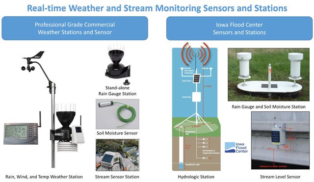
Monroe County Land Use Planner Roxie Anderson provided a summary of hydrologic monitoring and data hosting options for a local, statewide, and roadside detection/alerting program. There is also the possibility of participating in a developing regional initiative for the Upper Mississippi River watershed.
The options presented were based in the approach taken by the Iowa Flood Center who had made a presentation to the task force a couple of months before.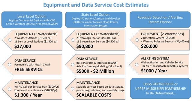

Local level option
In what is described as the ‘Local Level Option,’ there would be two weather stations ($1,500 each) and 16 bridge-mounted sensor stations ($1,500 each), at a total cost of $27,000. These stations and sensors would be mounted in locations in the headwaters of the Kickapoo and Little LaCrosse rivers, and the one proposed near Cashton would also provide information of value to residents of the Coon Creek watershed.
Estimated yearly maintenance costs for the devices would be $1,300 per year, which would include Wi-Fi/Cellular Service ($300/year) and equipment maintenance ($1,000/year). The data available through this option would be updated hourly, but could be updated every 15 minutes in emergency situations.
Each option discussed would require a data-hosting platform to aggregate the data and channel it into an interface that could be used by citizens, local first responders and even National Weather Service forecasters.
In the local option presented, the data would be housed free of charge by the National Weather Service through their ‘Citizen Weather Observer Program (CWOP).’ This is a public-private partnership with three goals: 1) to collect weather data contributed by citizens; 2) to make these data available for weather services and homeland security; and 3) to provide feedback to the data contributors so they have the tools to check and improve their data quality.
“Although we describe this as the local option, basically Monroe County would have difficulty even funding this least expensive option from our own resources,” Monroe County Conservationist Bob Micheel said. “Basically, we sort of see anything over $20,000 as being a state issue unless we can secure support from the private sector to fund the device purchases.”
Lieutenant Governor Mandela Barnes noted that the Wisconsin Climate Change Task Force was created through an executive order from Governor Tony Evers, without any funding approved for its activities or initiatives.

State level option
The state level option is based on the example of the Iowa Flood Center (IFC). The IFC had previously made a presentation to the Monroe CCTF about Iowa’s innovative approach to monitoring, forecasting, and making real time flood forecasts available to businesses and citizens.
For Monroe County to implement a state-level system for the Kickapoo and Little LaCrosse rivers, it would require an up front investment in monitoring equipment of $90,800. This would pay for two hydrologic stations ($9,400 each), and 16 stream level sensors ($4,500 each).
The data service, to be hosted by the state, would cost between $500,000 and $2 million (basic platform and interface - $500,000, or an advanced platform with modeling, $2 million). Maintenance is quantified as a ‘scalable cost,’ based on data storage, processing, retrieval and monthly usage.
Roadside detection/alerts
The roadside detection and alert option would focus on known flood problem areas. It would deploy two detection systems ($4,200 each) and four warning poles with beacons ($4,400 each). The detectors would sense when a flooding situation had made travel along a particular stretch of road unsafe and activate beacons to alert motorists that the road had become impassable.
The cost of the equipment for this alternative is $26,000. The cost of the alerting system, for web activation and cellular service would be $1,000 per year ($500 per system).
Regional option
The regional option would involve participation in a collaboration being developed between the IFC and the National Science Foundation. The scope of the collaboration would be the Upper Mississippi River Watershed. The system would manage and serve water quality and quantity data, and the platform would address the big data needs of several states. It would integrate data sets from multiple states that would otherwise have to be managed separately. This option is currently in development, and more information will become available in the near future.
Participant comments
Dave Vetrano, retired DNR Fisheries Biologist and member of Wisconsin Green Fire, weighed in on what he sees as a crucial aspect of reducing the amount of runoff in the local area.
“We need more perennial vegetation on our landscape, and more land in managed grazing, to take the peak off the flood pulse,” Vetrano stated. “Every increase in percent of soil organic matter results in increased capacity of our soils to hold water.”
Vetrano stated that he believes our area needs a renewed focus on increasing the amount of perennial vegetation on ridge top fields, focusing on increasing soil health, and a transition to regenerative agricultural production.
“The best thing that ever happened for the health of our groundwater and trout streams was the increase in acres in CRP after the 1980s,” Vetrano said. “Since 2007 land use in our area has changed radically with the decrease in pasture and hay, and fence-row-to-fence row plantings of corn and soybeans – land use now is completely different than it was during my career.”
One citizen asked if part of the solution was to plant more cover crops.
“We need to replace planting of row crops on steep slopes with perennial vegetation in order to reduce the amount of runoff in extreme rain events,” Monroe County Conservationist Bob Micheel said. “We need to determine what programs are out there that can facilitate that transition and the Land and Water Conservation Departments need to take a ‘whole farm’ focus in our efforts.”
Ron Luethe, aTown of Ridgeville Supervisor and member of the Monroe CCTF, made the point that it is crucial to get cover crops planted during the growing season in order to get establishment of roots in the soil before the cash crop is harvested.
“With our increasingly wet years, it has been harder and harder for farmers wanting to plant cover crops to get them planted in a timely fashion,” Luethe said. “And cover crops can help not only with reducing runoff, but also in preventing excess nutrients from getting into our groundwater. We need our farmers to become part of the partnership in protecting our ground and surface waters, and helping to reduce runoff.”
Marcy West, Executive Director of the Kickapoo Valley Reserve and recently appointed member of the Wisconsin Natural Resources Board, pointed out that the Governor’s recently announced rural prosperity initiative goes hand-in-hand with the kinds of things that were discussed at the meeting.
“We can only hope that our rural businesses can get the help that they need,” West said. “We need everyone to understand that the urban needs the rural, and the rural needs the urban.”
“We need to put our first focus on the short-term goals of increasing our monitoring abilities and getting warnings out to communities faster,” West said. “I think we need to reach out to our local business community to help get us started with getting monitoring stations in place, and then go from there. If we need an entity to receive and administer the funding, the old Kickapoo Valley Association still exists and could potentially function in that capacity.”
“I believe that we need to evolve this effort beyond county boundaries,” Micheel said. “We can’t have one county making decisions that affect everyone else in a watershed – we need to have all watershed stakeholders at the table together.”
Vernon County Board Supervisor Mary Henry attended the meeting.
“I’m just here to observe today,” Henry said. “Our county departments have been holding joint meetings, and I am here to see if this might be something we would want to consider doing in Vernon County as well.”
Dan Baumann, DNR Secretary’s Director for the West Central Region from the Eau Claire office, pointed out that the Mississippi River Regional Planning Commission (MRRPC) is already working on a flooding plan for the four counties included in the Kickapoo River Watershed.
Tim Hundt from U.S. Representative Ron Kind’s office noted that State Representative Loren Oldenburg has been working on legislation that would allow multiple counties to work together to form a Watershed Board.


